| |
|
Mountain Biking in the Akamas, Cyprus.
Think of Cyprus and you probably think of an increasingly popular (and populist) package holiday alternative to Spain. All sun sea and sand. Which is fair enough up to a point. But as you may also know (if you're reading this I expect you do anyway...) there is so much more to Cyprus than cheap packaged tat. (But don't expect to ever be much more than a stones' throw from it!)
If you're into Mountain Biking (and reading this means you most likely are) you probably also know that Cyprus offers some truly fantastic riding opportunities in its High Troodhos mountains. You may be thinking of heading off there, to spend time around the trails, basing yourself in the Mountain Bike Centre near Troodhos village, perhaps taking advantage of the guided tours and the jeep transfer back up the mountains after blasting down...
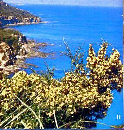
If that's the case, then great... but don't think that the High Troodhos is all Cyprus can offer the MTBer. If you're up in the mountains, look south west towards the sea and you'll see a lumpy peninsula jutting into the sea. This is the Akamas peninsula and it's a great MTB playground all it's own. Take a couple of days off from your downhilling and go explore it. Or, like we did, leave the mountains and all it's tourists behind totally, and devote yourself to playing in the wilderness.
If you're looking for somewhere to stay close to the Akamas wilderness then the chances are you'll end up in either Polis or Latchi. Both have their tourist sides... it's hard to find somewhere that doesn't to be honest. Both have villa type accommodation that is comfortable and I doubt they'll particularly object to you keeping your bikes in your rooms. If you feel flush with dosh why not take one with a swimming pool and then you can always take a dip to cool off when you return from the dusty trails. The benefit of the exercise shouldn't be overlooked either... If you're on a strict budget, there's a campsite in Polis, facilities on the good side. Close to the beach too, although depending on when exactly you visit the area, you've got to be aware of the delights of camping in hot conditions. Think about it...
Alternatively, and if you want to try getting closer to the Real Cyprus, check out the small ridge villages of the Akamas like Dhrousha and Inia.
The Routes
All the routes we took basically had the same starting point: the village of Neokhorio, or Neo Chorio, or Neon Chorion depending on which signpost or map you believe...they're all the same place, and it's at the top of a road climb that makes for a neat warm up (although with temperatures up in the high 80s when we were there I'm not so sure that's the correct phrase to use...). If you're staying in Polis then it's about 8km to Neokhorio, around half that from Latsi. The road surface is good and certainly from after the turn off to the Baths of Aphrodite ought to be very quiet. Not many tourists venture this far with cars and mostly it'll be locals in 4WD trucks who pass you looking at you like you're crazy. Contrary to popular opinion about Mediterranean drivers we found them all to be pretty friendly and no-one cut us up... a few horns honking and some blokey shouts to female riders is to be expected, but where is that not the case, sadly? Riding through Neon Chorion is a pleasure, as it is indeed through all the high villages where tourists seldom visit, even these days. It can be easy to slip into thinking you went through a timewarp when you passed the last holiday villas... the village men sitting outside the taverna drinking coffee, an old woman in black making lace on a loom in an open doorway, a old man walking his laden donkey, and if it's Sunday and you're lucky you might catch sight of a priest in black robes and obligatory white beard walking to the church which has loudspeakers on the outside wall proclaiming, well whatever it is that the Greek Orthodox church proclaims. I ain't too up on religion other than that of two wheels and dirt... So yeah... keep riding through the village on the road until you climb up a last steep incline, with the road veering left. The metaled road runs out here more or less, and turns slowly into a dirt track that forks. Left or right? Well I'd suggest you take the right fork towards the signposted 'Symies picnic ground'.... we took the left fork one day and after passing through a goat yard we ended up more or less lost, trailing on neat tracks and having a lot of fun, but let's be honest, not knowing where the hell we were or were going to end up. A woman coming the other way down a dirt road from hell stopped her 4WD Toyota and shouted at us, but it was all Greek to us! (ha ha, the oldest jokes are always the, erm, oldest.) I think she wanted to know what on earth we were doing, and where we were going. We just kinda shrugged and smiled but couldn't really communicate the fact that we were just two crazy english mountain bikers out for a laugh in the mountains. She pointed in the direction we were going and yelled voiciferously 'LARA! LARA!' and then she too shrugged and drove off. I checked my map, such as it was, and saw that Lara was a place on the coast, the other side of the line of hills we were on. Our dirt track was not marked. We decided that if we went on to Lara it would mean having to climb the Akamas again to get back and that on our first ride this was a poor idea... We turned and followed the Lara woman's dust trail back to Neon Chorion.
But take the signposted right track and you'll have a fine time! And you'll also know pretty much where you are... It's about another 5km from Neon Chorion to the Symies picnic sight, and the track is good quality, if a little churned by 4WDs in places. Half way along the track you pass the tiny Ayios Minas church, one of the one hundred discovered churches in the Akamas region. Legend says there are one hundred and one, but the last has yet to be discovered. Most of the found churches are almost inaccessible, many with no tracks leading to them at all, and some even found inside caves. It seems that at one time the region was a veritable religious goldmine.
The Symies picnic site is a great rest point, whether your body needs one or not! The two weeks we were there coincided with the local holiday period and consequently there were often a lot of Cypriot families enjoying the shade of the trees, cooking kebabs on the huge open barbecue pit, drinking, singing, kids playing... It's a heart warming sight. The locals are also friendly to visitors, and mountain bikes are an unusual sight so you can expect to get into some kind of pidgin english conversation, and to be offered food and drink. A bind if, like us, you're vegetarian, but at least the beer goes down well. The local beer is called Keo and has a label that says Be Happy, Drink Well. Seemed good advice to us.
Climb out the picnic site and you come to another fork, with a terrific view over to the south west coast. This is where you make your first real choice of direction. Lets go right first of all... The track climbs slightly and hugs the side of the mountain as you ride roughly North. Shortly you will come across a junction with a track which more or less switchbacks to your right. The main track goes straight on, but it's worth taking a short detour up this other track as it will take you to the Fire Lookout station, affording quite fantastic views across much of the Akamas wilderness. There is a barrier across this track but it was always open when I rode up, and no-one ever said that I shouldn't be there so it shouldn't be a problem. In fact the first time I rode this way a local in his truck stopped and seemed desperate to give me a lift to the top! If you feel like a rest it can be fun taking such offers, but on this occasion I laughed and said no thanks, then he laughed and made a sign that obviously meant he thought I was crazy. Like I said before, you get a lot of that in the Akamas. The climb to the lookout station is steep and a bit of a scramble at times, but it's eminently rideable. The views, as I said, are quite fantastic although I wouldn't stand around too long as even in the height of summer there will be a strong chilling wind blowing from the south west off the sea. So enjoy the views, take your snaps and dive back on the bike for the screaming descent. There shouldn't be any other traffic on the main track (but listen and look as you hammer down the last stretch to the junction... I passed a Fire Truck coming up one time so be careful!) so you can hammer straight down and away back on your original pre-detour route. The track starts to break up in places over the next few undulating kilometres and it's a test to find the best lines through the rocks and ruts. If you push it hard you should have a great time!
In time you will come to one of the ubiquitous British Army notices, a large sign that tells you not to go into the region when the red flags are flying and not to pick up anything metal on the ground "as it may explode and kill you". (Those of you who ride on Army Firing ranges in the UK will be familiar with this I know!) This sign is also vandalised, depressingly with obviously British graffiti that lists soccer teams such as Rangers and Liverpool which rather ruins the feeling of being in a wilderness, but there you go. Somewhat bizarrely there is also graffiti scratched on the sign that says, simply, "Kurdistan". Weird shit. At this sign there is also a fork to the track. Facing the sign, take the right hand track, which is more obviously the extension of the one you've just been riding. At the base of another short scrambly descent there is a choice to make. For now lets leave the track that goes left up to the summit of the very obvious Mouti tis Sotiras (the one that looks from most angles to be the highest of all the range, but in fact at 370m is nearly 300m lower than the actual high point - more of which later - and certainly not as high as you were at the lookout station. A question of perspective I guess.) and take the right hand track that should be signposted as leading to 'Pyrgos tis Riyenas'. This will shortly lead you to a small picnic site and the remains of a Byzantine Monastery or a Lusignan fort, depending on who you believe. The ruins are disappointing and although there is a gaping hole in the metal fence that surrounds the ruins there's still not much to see when you go through it. It does make for a pleasant rest spot though, and as ever any locals picnicking there will look upon you with bemusement. Smile, say hello and you'll spend a friendly time practising your pidgin english again!
Getting back on the trail from Pyrgos tis Ryenas can be tricky unless you want to backtrack up to the junction at the base of Mouti tis Sotiras. There is a nature trail, the 'Aphrodite' trail, which leaves the site heading roughly east but it can be tricky to find. It's situated more or less directly opposite the ruins in a line that would run perpendicular to the main track. It's a dark red dirt singletrack that starts between a couple of bushes and then starts to negotiate a few rocks... Now basically you're going to be on this trail until you hit the coast. It's downhill, much of it rideable, but in places, well... I figure most people will be off and carrying down the toughest sections. At one point you will stop and enjoy the view out across the Khyrsokhou Bay and you'll see the trail stretching out arrow straight in front of you. The reason it's so straight and at that point relatively wide is that it is in fact an old firebreak. Something else you'll see is an alarming number of empty shotgun shell-cases, left by the locals illegally shooting the birds of the area. So be sensible and leave that new eagles head paintjob helmet at home. Of course you should be wearing a helmet for this type of riding, even if it does feel like your head is boiling. If you can, obviously try and wear one with as much ventilation as possible. I took my new Air Piranha and it felt just perfect... if you have the dosh it's well recommended. So yeah, riding the 'Aphrodite' trail to the coast: BE CAREFUL. It would be really easy to throw caution to the wind and think you're Nico Vuilloz or Missy and go hurtling over these rocks, but remember that you probably aren't either of those people and that anyway, this isn't a race and that if you crash here you're likely to regret it. One thing that locals told us was that because the Akamas is a designated wilderness area / nature reserve, then apparently you won't be insured against any accidents which might befall you. Indeed as you approach the Symies picnic site you will probably see a sign that advises you that you enter the area 'at your own risk'. Bear it in mind. Err to the side of caution rather than bravery and you'll be okay. Not to say of course that you won't have a bloody great buzz from riding as much of the trail as you can, just that to remember to ride within your limits. It's not the place to go testing yourself or your equipment. Think on...
So you hammer along the old firebreak and scream to a halt in a little round clearing that has an old metal framed bench looking out east to the bay. Look to your left and you should see the continuation of the trail, this time on chalky white soil. You're now on the last section to the coast, and it switchbacks and drops through precipitous boulders that you really ought to carry over, until you finally reach civilisation again in the form of a campsite that seems to have been erected by the holidaying Cypriots. If you're lucky like we were then you could be greeted by a local farmer in his vineyard who might well offer you some of his grapes. Believe me, they taste beautifully sweet after the dusty trail!
Turning right takes you onto the last section of the Fontana Amorosa track (more about that shortly) and then swiftly onto the main road at the Baths of Aphrodite. The 'actual' Baths of Aphrodite can be reached in a few minutes up the obvious paved track, and is a very pretty little pool fed by water which drips down the face of the rock in a grotto which is covered in fig trees. It's going to be busy as hell during the main hours of the day, so I suggest you get there early morning to see it with no-one else around. We were there around 8am and it was lovely. But just resist the temptation to paddle or re-fill your camelback from the pool!
From the Baths it's a straight road ride back along the coast, to join the main road to Latsi and Polis. A chance to warm down and ease up on the aching muscles. Maybe stop for IceCream in Latsi if no-one objects too much to sweaty dusty MTBers, and then think about what route to do tomorrow...
Backtrack.... You're at the track junction at the base of Mouti tis Sotiras, as mentioned previously. This time, instead of heading for Pyrgos tis Ryenas, take the track that heads up the mountain. It's fairly steep and a bit technical to begin with but it evens out for a while and you can spin along the relatively smooth trail until it rises sharply again in a white rocky section. Once up and over this, the trail is narrow and ill defined, threading through rocks and boulders, eventually rising through thorny bushes to the wind swept summit and the breathtaking view out towards Cape Arnauti, the very end of the Akamas peninsula. This view is a popular postcard picture and it's worth the slog up to see it for yourself. The rocky summit that you sit on is called a 'suicide leap' in some guide books. Whether this is a literal title I don't know, but I certainly wouldn't rate your chances of survival if you slid off the ledge. It's a long way down, and the wind does seem to push you towards the edge. Not for the faint hearted. When you do look over the edge however you will see what appears to be a screaming piece of singletrack snaking down the side of the mountain. Good news is that this is what you're heading for next! Avoid a mammoth drop off from the cliff top and retrace your tyre tracks until you reach the signed junction that shows the start of the singletrack that descends to the coast. Head off on this and you'll be switchbacking down the seaward facing slope of the mountain, getting huge adrenalin rushes and hopefully too not taking any risks. Remember the 'at your own risk' signs... You should be wary too of possible walkers either coming up towards you or going down ahead of you. This track is part of the 'Aphrodite' nature trail, and is used by walkers as well as crazed bikers.
Off the singletrack descent you join up to the Fontana Amorosa coastal track. This is a dirt track that runs from the Baths of Aphrodite right out to Cape Arnauti, and is worth riding at least once, although probably not more, as there isn't a great deal to see on the route, particularly when you're past the base of Mouti tis Sotiras. That said, if there was a gang of you then you could definitely have a great laugh playing around at some of the churned up sections. There are some magic natural launch pads to be found, and as it's so deserted here you're not going to be causing anyone any hassles. Also, such is the damage caused to the track by 4WDs and the like, you're unlikely to cause any more grief with your own rubber. Just ensure you don't fly off the trail and damage the flora or fauna... not that there'll be much of that in the height of summer anyway.
If you trail all the way out to Cape Arnauti you'll be rewarded with the fact that you reached the end on the Akamas, and by a fairly violent sea, which comes as somewhat of a surprise after all the tranquil bays you passed along the way. Also out at the Cape is the wreck of an old freighter which ran aground here in the early 80s. Until a few years ago it was still more or less intact apparently, but then the British Army decided to use the wreck as target practice and all but destroyed it. These days pretty much all you see is a rusted bow sticking out of the sea.
All you can do from here is to retrace your tracks back towards the Baths of Aphrodite. If you rode out here alone you'll be able to see your own tyre tracks in the dirt really clearly. So few vehicles come out this far that they'll probably be there until the rains come. As you pass again under the shadow of Mouti tis Sotiras you'll start to encounter the trails undulations, which actually makes a pleasant respite after the fairly flat and dull blast in from the Cape. The track gets more rugged, rutted and rocky and makes a fine challenge on the climbs. Don't overshoot any corners on the descent on this section though as it's a fair drop to the sea from the edge of the track. But do take a moment to stop and look upwards at the mountainside above you. If you look carefully you will see a tiny building clinging to the mountainside, and yes, it's another one of those 101 Akamas churches. This one is Ayios Georgios, and the little island in the bay at this point is called, surprise surprise, Ayios Georgios Island.
Soon enough you'll find yourself back at the Baths of Aphrodite, and again the ride on the coast road 'home'. You might want to spend a few minutes at the Tourist Pavillion here, and as you ride round the bend away from it, watch out for the dogs that live in the cottage on the left... pumps to the ready and time to muster a sprint. Thankfully these were about the only dogs we ever encountered in our two weeks.
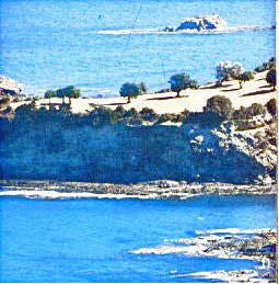
Okay, back to the Symies picnic ground, and the junction just beyond. You now know what happens if you go right, but what if you go left? Good question... Left here gives you almost immediately a choice of two tracks. Take the slightly better looking right hand track signed for 'Lara' and get ready for a magic blast of a downhill. Wide dirt road, good traction on the bends, nice straights to get the biggest gear spinning and loads of little humps to use for airtime if you feel so inclined, and lets face it, who wouldn't? You can also be pretty much assured that you're not going to meet anything coming up the other way, although how much you take that for granted I'll leave up to you. When you hit the bottom you'll be a quivering mass of jelly, and the rutted dirt 'road' that runs along this south west coast is a bit of a juddering pain in the butt, even with suspension. The British Army use the road to pull big guns, and probably tanks too for all I know out to their firing range, and it's taken it's toll on the surface. It's not that bad, but it's not a very interesting stretch for around 8km so you tend to notice every lump there is. After around 6km you'll come to what is by now for us the infamous 'Lara' bay. There's actually very little here except for one taverna facing the southern beach and a turtle nesting centre on the north beach. This beach particularly is beautiful, although much is fenced off to protect the turtles' nests, and the gate is locked at sensitive times of the year. You'd be hard pushed to find a better beach and a more peaceful spot to rest and take a dip in the sea, but watch out for getting that beautiful soft sand in your transmission...
Carry on south from Lara and after a couple more kilometres you'll come across the entrance to the Avgas gorge. You can't really miss it as there's a fairly big sign at the foot of the track notifying you of the taverna that sits up on the cliffs above you. The track climbs and when you see the junction to the taverna you should go straight on if you want to go straight to the gorge. However I'd urge you to visit the taverna first: it's run by a friendly chap called Savvas, and it's well worth the extra climb to visit him. I actually couldn't avoid him, as he arrived at the start of the track in his truck at the same moment I did. He positively insisted I load my bike in the back and ride with him to his taverna, as he told me about the gorge and the surrounding area. He also very helpfully pointed out exactly which was the Avgas gorge... basically it's the left hand of the two tracks you eventually come to if you carry on past the junction to his place. A lot of first timers get it wrong. I guess I probably would have too. The gorge itself is good to see, although I expect it's a lot more enjoyable in spring when there are more flowers about. As it was there was some lovely Bougainvillaea, although nothing compared to the majestic mass of pink that arched around the entrance to Savvas' place. If you feel like a real hike you can squeeze through the gorge where it narrows and crosses a stream, but I'd advise against it if you want to keep your legs scratch free. It's just too narrow to walk carrying a bike and avoid the thorns and sharp rocks. Better to just enjoy the shade a moment, drink and then head back towards the coast. The bone rattling descent is a real blast, but watch out for your bottles... I lost a full bottle of Isostar into the impenetrable thorny bushes somewhere along the way and didn't even notice that it had gone missing until I slowed at the bottom. Even though I'd set out with two full large bottles and a full Camelbak I still felt a touch worried about how much I had left to get me over the mountains back to Polis.
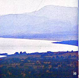
Back over the mountains... there's several ways to do this. You could do the boring roadie bit and head south further along the dirt road until it becomes a metaled road just after Cape Dhrepano, and climb on road through Peyia, Kathikas and finally Dhrousia until you hit the super fast road descent into Polis. But where's the fun in that, right? Alternatively you could backtrack all the way up past Lara and climb the track you came down from the Symies picnic site. This would be the easiest off road climb, crossing as it does the lowest saddle on the Akamas ridge, but again, where's the fun in riding a track you just came down? Better by far to choose one of the more demanding climbs over the Akamas... There are two tracks that head up to more or less the same point on the mountain ridge, and both are signposted to 'Inia/Dhroushia'. The one I took is the first one that you encounter branching right off the main dirt road as you head North again back from Avgas towards Lara. It's a long, hard and very hot climb from the coast that goes to as near as damn it the summit of Ayios Yeoryios, at 669m the highest point on the Akamas range. Starting from the coast means too that you climb up as near as damn it every single one of those 669 metres. The track surface is pretty good, and would probably be a dreamy fast downhill going the other way. But you're going uphill, and if you're as foolish as I was to attempt it at around midday in mid August then make sure you haven't just lost a full bottle of fluid down a gorge. Normally I love climbs in a perverse kind of way, but this one really bust me big time. I was forced to walk sections of it, not because it was too technical, or even particularly steep, but just because I felt so hot and tired. There was of course the prevailing tail wind blowing from the coast to help me, but in reality it was more of a hindrance, just conspiring to make it feel even hotter and giving the illusion that it was actually blowing the air away from me. You think some pretty dumb things when you're getting exhausted, don't you? Towards the summit though I started to get it together again and recovered enough to ride the last section up and over the ridge. Basically at this point you're following the track until it starts to curve to the south and then forks in two, with the wider trail heading down and the narrower forking left and up again. Take the left track but don't be fooled into thinking you're at the summit... you've still a bit of climbing to go yet. As the track veers north east again you'll get a glorious view across to the villages of Inia and Kato and Pano Arodhes (Kato and Pano mean 'High' and 'Low') clinging to the mountain side, just below the ridge. Don't, however take the track the heads in their direction, but veer left up towards the radio masts that mark the summit of Ayios Yeryios. The track splits right before you reach the masts, so you don't go all the way to the summit unless you fancy a detour (and I certainly didn't!), and then quickly starts to descend to join a wider dirt road. This dirt road is a track which runs from the village of Dhroushia along the ridge to the point near Symies at which you started your ride down to Lara earlier in the day, but you should avoid going straight along it and instead take the almost immediately apparent track that heads right and down the mountainside to the valley. If you pause a moment here you'll be able to see Polis and the bay below, and in the further distance to the east you'll see the mountains of the High Troodhos.
You could at this point make another short detour if time, strength and fluid permit, and ride south east along the dirt road back to the village of Dhroushia. Here, should you have money and time you can rest and drink at the local cafe. You can also watch the local men play dominoes. The village feels similar in atmosphere to Neon Chorion but is a lot easier to get lost in. There seems to be a myriad of narrow streets that all seem to go around in circles, and all come back to the cafe! If you can't find your way back to the dirt road ask the locals for directions. Tell them you want to go to Fasli, and they'll point out which side street to take!
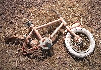
Fasli (or Phasli) is the first of two 'villages' that you come across when you take the aforementioned right hand track off the main dirt road. The trail is basically one big fast downhill of near on 8km all the way to Polis, another endorphin blast that is punctuated by the farm 'house' of one goatherding old couple that you may see on their donkeys if you're lucky, and two strange 'villages' on the way down. As mentioned, Fasli is the first of these 'villages', and is little more than a few derelict cottages grouped around a cobbled switchback on the track. The second village, however, is a different matter. It really is incredibly eerie, you don't know whether to slow up and gawp or speed up and blast through. It really is ghostlike. The village is (was?) called Androlikou, I rode through it on this descent twice, and both times were totally different. The first time took my breath away because there were goats everywhere, and I mean everywhere! Running across the deserted streets, standing in deserted buildings, jumping off walls of derelict gas stations. If you come through and see a similar sight then slow right down and take it very easy until you're out of the village and clear of the herd. It's bound to as scary for the goats as it is for you! And if there are no goats, well, slow down anyway. Stop. Look at the empty shells of buildings and the wrecked cars. See if you can find the rusting old kiddies bike by the side of the track. Look at the place and wonder how this sort of thing happens... Is it what happens when politicians exploit the tensions between religions and cultural groups? Or is it a natural breakdown of a society that was always built on a rickety foundation anyway? You'll find no end of opinion on Cyprus still, but somehow the 'reasons' don't matter much when you stand there and look at the desolation and emptiness around you. Families and lives uprooted, displaced. And although it may have all happened over twenty years ago it remains a creepy place. I doubt you'll want to hang around... goats or no goats.
Thankfully you quickly get up to speed when leaving Androlikou and it's more downhill fest through a dip past a magnesium mine and a strangely situated war memorial, up a last small incline and then down again on a chalky track that soon turns to metaled road and the last few kilometres of smooth road to Polis. Probably a good five hour ride, with just a few short stops, but bargain on a whole long day if you're going to take a dip at Lara, stop for lunch and really see places.
Alistair Fitchett. 1995. |